Summary
ATTENTION: Make sure your automated translation is disabled in your browser.
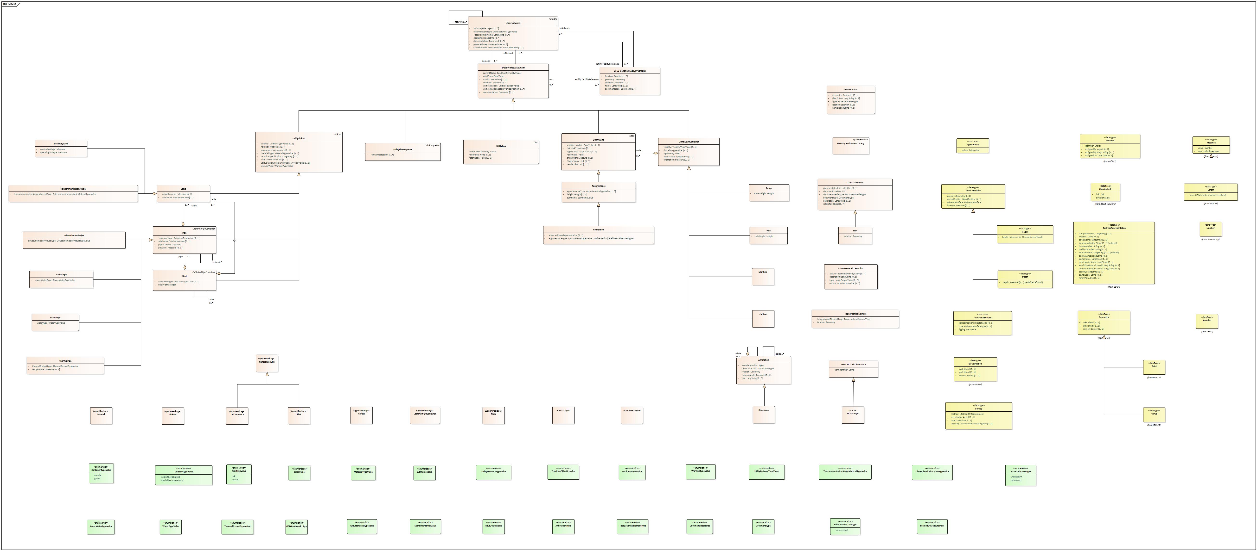
The ICEG Cables and Pipes application profile shows how terms from the associated vocabulary should be used to describe cables and pipes/ducts. This application model is based on the IMKL Cables and Pipes Information Model.
These can be located both above and below ground. As far as the underground cables and pipes or ducts are concerned, the description is such that all elements are present that contribute to limiting excavation damage.
The model builds on INSPIRE Utility Services and models on which that model is based, mainly INSPIRE Networks.
Utilities such as cables and pipes or ducts are conceived as a network (a UtilityNetwork) in which they form linear elements, connected by point objects such as splitters, connectors, connections mounted in or on cabinets, towers, poles, etc.
Cables and pipes or ducts are collections of links in the network, UtilityLinkSets composed of UtilityLinkSequences or Links. The main types of link sets are Cables, Pipes and Ducts. Pipes and Ducts are conduits: they carry substances such as water, waste water, gas or contain Cables or other Pipes or Ducts.
The Cables class is divided into Electrical Cables and Telecommunications Cables. In Pipes, a distinction is made between OilGasChemicalsPipes, Sewer Pipes, Water Pipes and Thermal Pipes.
The point objects that realize the connections in the network (For example couplings, connections, pumps, meters) are the nodes of the network, the so-called Utility Nodes. They can stand alone but are typically mounted on larger sized point objects such as Poles or Towers or sit in Cabinets on the street. We call these Utility Node Containers.
Some Utility Elements together form a facility or installation that can be separately described as an Activity Complex.
The model includes various supporting classes and data types, including to supplement the network information with topographical information (class Topographic Element) or zones where digging is not allowed (class Protected Area) or to annotate the objects (class Annotation).
The geometry of cables and pipes and nodes in the network can be described in 2D or 2.5D.
If 2.5D is not possible or is insufficient, additional information about the VerticalPosition can be provided, both relative (to a Reference Surface) and absolute (Direct Position in a vertical coordinate system such as TAW). This information is important to avoid excavation damage.
Status of this document
This application profile has the status Onbekend and was published at 2024-02-06.
Conformance
To be defined
Overview
This document describes the usage of the following entities for a correct usage of the application profile:
|
Activity Complex |
Address |
Agent |
Annotation |
Appurtenance |
Cabinet |
Cable |
Cable and Pipe Container |
Connection |
Dimension |
Document |
Duct |
Electricity Cable |
Function |
Generic Link |
Link |
Link Sequence |
Link Set |
Manhole |
Network |
Node |
Object |
Oil Gas Chemicals Pipe |
Pipe |
Plan |
Pole |
Positional Accuracy |
Protected Area |
Sewer Pipe |
Telecommunications Cable |
Thermal Pipe |
Topographical Element |
Tower |
Unit of Measure |
UOM Length |
Utility Link |
Utility Link Sequence |
Utility Link Set |
Utility Network |
Utility Network Element |
Utility Node |
Utility Node Container |
Water Pipe |
This document describes the usage of the following datatypes for a correct usage of the application profile:
|
Address Representation |
Appearance |
Curve |
Depth |
Direct Position |
Directed Link |
Geometry |
Height |
Identifier |
Length |
Location |
Measure |
Number |
Point |
Reference Surface |
Survey |
Vertical Position |
Entities
Activity Complex
- Definition
- Technical and economic unit managed by the same operator where certain activities regarding production and services take place.
- Usage
- In practice, a site, plot, facility, installation, building where the activity takes place. In the context of cables and pipes, it refers to For example a power plant, a pumping station, a sewage treatment plant, etc. Includes the infrastructure, equipment and material required for it. May include several sites as long as they are part of the same complex. The activity is preferably identified by NACE codes.
- Properties
- For this entity the following properties are defined: documentation, function, geometry, identifier, in network, name, on.
| Property | Expected Range | Cardinality | Definition | Usage | Codelist |
|---|---|---|---|---|---|
documentation
|
Document | 0..* | Reference to a Document with additional information about the complex. | ||
function
|
Function | 1..* | Activities carried out by the complex. | Possibly supplemented with information about inputs and outputs of the activities. | |
geometry
|
Geometry | 1 | Geometry of the complex to describe its location and size. | ||
identifier
|
Identifier | 1..* | External Identifier of the complex. | NOTE An external object identifier is a unique object identifier published by the responsible body, which may be used by external applications to reference the spatial object. The identifier is an identifier of the spatial object, not an identifier of the real-world phenomenon. | |
in network
|
Utility Network | 1..* | Utility Network to which the Activity Complex belongs. | ||
name
|
LangString | 0..1 | Name by which the complex is known. | NOTE 1 Several names in different languages may be expressed. NOTE 2 It is recommended that the language of the name (part of the Geographical/Name data type) be filled whenever possible. | |
on
|
Utility Network Element | 0..* | Utility Network Element belonging to the complex. |
Address
- Definition
- Information that allows to refer in a structured and unique way to a building unit,a berth,a pitch or a plot based on a municipal name,a street name,a house number and possibly a bus number and a postal code.
- Usage
- The definition refers to Belgian addresses. In other countries, an address may refer to other geographical objects (not a building unit or a plot of land) or consist of other designations (different from house number and bus number) or of other components than street name, town name or postal code. Alternative address designations than house number or bus number (For example entrance designation, stair designation, floor designation) or a building name or room name etc are possible through an association with address extension. Exchange of foreign addresses must be done with the object address representation.
- Properties
- No properties have been defined for this entity.
Agent
- Definition
- Someone or something that can act or produce an effect.
- Properties
- No properties have been defined for this entity.
Annotation
- Definition
- A short explanation or note added to an Object.
- Usage
- In this context, typically a Dimension on a cable or pipe map, for example the distance of a cable to a facade. Can consist of parts (For example dimensioning line, dimensioning guideline, two arrows) that are also Annotations in themselves.
- Properties
- For this entity the following properties are defined: annotation type, associated with, location, part, rotation angle, text, whole.
| Property | Expected Range | Cardinality | Definition | Usage | Codelist |
|---|---|---|---|---|---|
annotation type
|
Annotation Type | 1 | Classification of the Annotation. | In this context, typically a Dimension on a cable or pipe map, for example the distance of a cable to a facade. Can consist of parts (For example dimensioning line, dimensioning guideline, two arrows) that are also Annotations in themselves. | |
associated with
|
Object | 1 | Object to which the Annotation refers. | For example a cable. | |
location
|
Geometry | 1 | Geometry of the Annotation. | For example the location and shape of a Dimension. | |
part
|
Annotation | 0..* | Annotation that is part of the Annotation. | For example the dimension line in the case of a Dimension, consisting of two arrows and a dimension guide line. | |
rotation angle
|
Measure | 0..1 | Angle by which the Annotation should be rotated when displayed. | Typically to align the Annotation with the Object it relates to, for example parallel to the cable. | |
text
|
LangString | 0..* | Text of the Annotation. | For example the size in the case of a Dimension. | |
whole
|
Annotation | 0..* | Annotation of which the Annotation is a part. | For example the Dimension to which the dimension line belongs. |
Appurtenance
- Definition
- Physical point-shaped part of the UtilityNetwork.
- Usage
- Can stand alone as a Utility Node, but is often mounted on a carrier (the Utility Node Container). For example an inspection hatch, a hydrant, a splitter, a meter, a pump etc.
- Subclass of
- Utility Node
- Properties
- For this entity the following properties are defined: appurtenance type, height, subtheme.
| Property | Expected Range | Cardinality | Definition | Usage | Codelist |
|---|---|---|---|---|---|
appurtenance type
|
Appurtenance Type Value | 1..* | Type of Appurtenance. | ||
height
|
Length | 0..1 | The height of the Appurtenance. | ||
subtheme
|
Subtheme Value | 1 | Classification of a Appurtunance according to the thematic domain to which they belong. |
Cabinet
- Definition
- Simple Utility Node Container that takes the shape of a cabinet.
- Usage
- Contains typically smaller mountable Appurtenances and Cables.
- Subclass of
- Utility Node Container
- Properties
- No properties have been defined for this entity.
Cable
- Definition
- A Utility Link Set used to transmit electricity or data from one location to another.
- Subclass of
- Utility Link Set
- Properties
- For this entity the following properties are defined: cable diameter, subtheme.
| Property | Expected Range | Cardinality | Definition | Usage | Codelist |
|---|---|---|---|---|---|
cable diameter
|
Measure | 0..1 | Diameter of the Cable. | ||
subtheme
|
Subtheme Value | 0..1 | Classification of a cable, pipe, or pipe elements according to the thematic domain to which they belong. |
Cable and Pipe Container
- Definition
- Object that could potentially contain cables and/or pipes/ducts.
- Usage
- For example, if the object is a Pipe: a Pipe can include Cables or other Pipes. Analogous for pipes of the Duct type. Cables are not Cable and Pipe Containers. NOTE: whether the Cable and Pipe Container ultimately contains other elements is indicated by the outgoing relations to those other relations (For example Channel.pipe, Pipe.cable, Channel.cable, Pipe.pipe etc).
- Properties
- No properties have been defined for this entity.
Connection
- Definition
- Object describing the connection of a cable or pipe to a building or other physical object.
- Subclass of
- Appurtenance
- Properties
- For this entity the following properties are defined: address, appurtenance type.
| Property | Expected Range | Cardinality | Definition | Usage | Codelist |
|---|---|---|---|---|---|
address
|
Address Representation | 0..1 | Address of the Connection. | ||
appurtenance type
|
Appurtenance Type Value | 1 | Appurtenance classification. |
Dimension
- Definition
- Type of Annotation that indicates the size of an Object.
- Usage
- For example, the dimensions of a room.
- Subclass of
- Annotation
- Properties
- No properties have been defined for this entity.
Document
- Definition
- Information recorded on a data carrier.
- Properties
- For this entity the following properties are defined: description, document identifier, document location, document mediatype, document type, refers to.
| Property | Expected Range | Cardinality | Definition | Usage | Codelist |
|---|---|---|---|---|---|
description
|
LangString | 0..1 | Description of the Document. | ||
document identifier
|
Identifier | 0..1 | Identifier of the Document. | ||
document location
|
URI | 1 | The place where the Document is stored or can be consulted. | ||
document mediatype
|
Document Mediatype | 1 | Nature of the data carrier on which the Document is stored. | ||
document type
|
Document Type | 1 | Classification of the document. | ||
refers to
|
Object | 0..* | Object to which the document refers. |
Duct
- Definition
- A Utility Link Set used to protect and route cables and pipes through an enclosing structure.
- Usage
- A Duct (or Conduit, or Duct-bank, or Wireway) is a linear object which belongs to the structural network. It is the outermost casing. A Duct may contain Pipe(s), Cable(s) or other Duct(s).
- Subclass of
- Utility Link Set, CableAndPipeContainer
- Properties
- For this entity the following properties are defined: cable, container type, duct, duct width, pipe.
| Property | Expected Range | Cardinality | Definition | Usage | Codelist |
|---|---|---|---|---|---|
cable
|
Cable | 0..* | Cable located in the Duct. | ||
container type
|
Container Type Value | 0..1 | Type of the Duct as a container. | ||
duct
|
Duct | 0..* | Duct located in the Duct. | ||
duct width
|
Length | 1 | Width of the Duct. | The measurement of the object - in this case, the duct - from side to side. | |
pipe
|
Pipe | 0..* | Pipe located in the Duct. |
Electricity Cable
- Definition
- A Cable used to transport electricity from one location to another.
- Subclass of
- Cable
- Properties
- For this entity the following properties are defined: nominal voltage, operating voltage.
| Property | Expected Range | Cardinality | Definition | Usage | Codelist |
|---|---|---|---|---|---|
nominal voltage
|
Measure | 1 | Voltage without load. | ||
operating voltage
|
Measure | 1 | Voltage during load. |
Function
- Definition
- The function of something expressed as an activity and optional input and/or output.
- Properties
- For this entity the following properties are defined: activity, description, input, output.
| Property | Expected Range | Cardinality | Definition | Usage | Codelist |
|---|---|---|---|---|---|
activity
|
Economic Activity Value | 1..* | Classification of the activity. | Preferably use the NACE codes. | |
description
|
LangString | 0..1 | A more detailed description of the function. | ||
input
|
Input Output Value | 0..* | Input for the activity in the function. | ||
output
|
Input Output Value | 0..* | Output the result of the activity in the function. |
Generic Link
- Definition
- Linear Network Element.
- Properties
- No properties have been defined for this entity.
Link
- Definition
- Curvilinear network element that connects two positions and represents a homogeneous path in the Network. The connected positions are represented by Nodes.
- Subclass of
- Generic Link
- Properties
- No properties have been defined for this entity.
Link Sequence
- Definition
- Unbranched continuous path in a Network.
- Usage
- For example, a route in the Network.
- Subclass of
- Generic Link
- Properties
- No properties have been defined for this entity.
Link Set
- Definition
- Collection of Link Sequences and/or Links with a specific function or interest in the Network.
- Properties
- No properties have been defined for this entity.
Manhole
- Definition
- Simple Utility Node Container that takes the form of a covered opening in the road surface providing access to the subsurface.
- Usage
- For example sewer cover.
- Subclass of
- Utility Node Container
- Properties
- No properties have been defined for this entity.
Network
- Definition
- Collection of Network Elements.
- Usage
- The reason why the Network Elements are brought together in a Network may differ, for example because they are suitable for a certain type of transport.
- Properties
- No properties have been defined for this entity.
Node
- Definition
- Significant position in the Network that always coincides with the beginning or end of a Link.
- Properties
- No properties have been defined for this entity.
Object
- Definition
- Entity from which all entities are derived.
- Properties
- No properties have been defined for this entity.
Oil Gas Chemicals Pipe
- Definition
- A pipe used to transport oil, gas or chemicals from one location to another.
- Subclass of
- Pipe
- Properties
- For this entity the following properties are defined: oil gas chemicals product type.
| Property | Expected Range | Cardinality | Definition | Usage | Codelist |
|---|---|---|---|---|---|
oil gas chemicals product type
|
Oil Gas Chemicals Product Type Value | 1 | The type of oil, gas or chemical product transported through the oil, gas or chemical pipe. |
Pipe
- Definition
- A Utility Link Set intended for the transportation of solids, liquids, chemicals or gases from one location to another or as a casing for Cables or other Pipes.
- Subclass of
- Utility Link Set, CableAndPipeContainer
- Properties
- For this entity the following properties are defined: cable, container type, pipe, pipe diameter, pressure, subtheme.
| Property | Expected Range | Cardinality | Definition | Usage | Codelist |
|---|---|---|---|---|---|
cable
|
Cable | 0..* | Cable located in the Pipe. | ||
container type
|
Container Type Value | 0..1 | Type of the Pipe as a container. | ||
pipe
|
Pipe | 0..* | Other Pipe located in the Pipe. | ||
pipe diameter
|
Measure | 1 | Outer diameter of the Pipe. | For convex shaped objects (For example a circle) the diameter is defined to be the largest distance that can be formed between two opposite parallel lines tangent to its boundery. | |
pressure
|
Measure | 0..1 | The maximum allowable operating pressure at which a product is transported through a Pipe. | The unit of measurement for pressure is usually expressed in 'bar'. | |
subtheme
|
Subtheme Value | 0..1 | Classification of the Pipe according to the thematic domain to which it belongs. |
Pole
- Definition
- Simple Utility Node Container that takes the shape of a pole.
- Usage
- Typical carrier of mountable Appurtenances and Cables.
- Subclass of
- Utility Node Container
- Properties
- For this entity the following properties are defined: pole height.
| Property | Expected Range | Cardinality | Definition | Usage | Codelist |
|---|---|---|---|---|---|
pole height
|
Length | 1 | The height of the Pole. |
Positional Accuracy
- Definition
- Degree to which a specified position represents the actual position.
- Usage
- For example, expressed as the maximum deviation in cm between both positions.
- Subclass of
- DQ_Element
- Properties
- No properties have been defined for this entity.
Protected Area
- Definition
- Area within which certain regulations apply when carrying out works.
- Properties
- For this entity the following properties are defined: description, geometry, location, name, type.
| Property | Expected Range | Cardinality | Definition | Usage | Codelist |
|---|---|---|---|---|---|
description
|
LangString | 0..1 | Description of the Protected Area. | ||
geometry
|
Geometry | 0..1 | Geometry of the Protected Area. | ||
location
|
Location | 0..1 | Location of the Protected Area. | ||
name
|
LangString | 0..1 | Name of the Protected Area. | ||
type
|
Protected Area Value | 1 | Classification of different types of protected areas. |
Sewer Pipe
- Definition
- A sewer pipe used to convey wastewater (sewer) from one location to another.
- Subclass of
- Pipe
- Properties
- For this entity the following properties are defined: sewer water type.
| Property | Expected Range | Cardinality | Definition | Usage | Codelist |
|---|---|---|---|---|---|
sewer water type
|
Sewer Water Type Value | 1 | Type of sewer water. |
Telecommunications Cable
- Definition
- A Utility Link or Link Sequence used to convey data signals (PSTN, radio or computer) from one location to another.
- Subclass of
- Cable
- Properties
- For this entity the following properties are defined: telecommunications cable material type.
| Property | Expected Range | Cardinality | Definition | Usage | Codelist |
|---|---|---|---|---|---|
telecommunications cable material type
|
Telecommunications Cable Material Type Value | 1 | Type of cable material. |
Thermal Pipe
- Definition
- A pipe used to disseminate heating or cooling from one location to another.
- Subclass of
- Pipe
- Properties
- For this entity the following properties are defined: temperature, thermal product type.
| Property | Expected Range | Cardinality | Definition | Usage | Codelist |
|---|---|---|---|---|---|
temperature
|
Measure | 0..1 | Temperature of the contents of the pipe. | ||
thermal product type
|
Thermal Product Type Value | 1 | The type of thermal product transported through the Thermal Pipe. |
Topographical Element
- Definition
- Part of the description of the shape and features of the earth's surface.
- Usage
- Typical elements are relief, landforms, water bodies, vegetation.
- Properties
- For this entity the following properties are defined: location, topographical element type.
| Property | Expected Range | Cardinality | Definition | Usage | Codelist |
|---|---|---|---|---|---|
location
|
Geometry | 1 | Shape and position features of an object, | Typical elements are relief, landforms, water bodies, vegetation. | |
topographical element type
|
Topographical Element Type | 1 | Type of the Topographical Element. |
Tower
- Definition
- Simple UtilityNodeContainer that takes the shape of a Tower.
- Usage
- Typical carrier of mountable Appurtenances and Cables.
- Subclass of
- Utility Node Container
- Properties
- For this entity the following properties are defined: tower height.
| Property | Expected Range | Cardinality | Definition | Usage | Codelist |
|---|---|---|---|---|---|
tower height
|
Length | 1 | Heigt of the Tower. |
Unit of Measure
- Definition
- Properties
- For this entity the following properties are defined: uom identifier.
| Property | Expected Range | Cardinality | Definition | Usage | Codelist |
|---|---|---|---|---|---|
uom identifier
|
String | 1 | Unit identifier. | For example m for meter. |
UOM Length
- Definition
- Subclass of
- Unit of Measure
- Properties
- No properties have been defined for this entity.
Utility Link
- Definition
- A linear spatial object that describes the geometry and connectivity between two points in a Utility Network.
- Subclass of
- Utility Network Element, Link
- Properties
- For this entity the following properties are defined: centreline geometry, end node, in network, start node.
| Property | Expected Range | Cardinality | Definition | Usage | Codelist |
|---|---|---|---|---|---|
centreline geometry
|
Curve | 1 | The geometry of the centerline of the Link. | ||
end node
|
Node | 0..1 | Node that is the end of the Link. | ||
in network
|
Utility Network | 1..* | Utility Network to which the element belongs. | ||
start node
|
Node | 0..1 | Node that starts the Link. |
Utility Link Sequence
- Definition
- An unbranched continuous path in the Utility Network.
- Usage
- In fact, a route in the network, for example a water pipe in the flow direction. Routes have a direction, which is why the Link Sequence is composed of Directed Links.
- Subclass of
- Utility Network Element, LinkSequence
- Properties
- For this entity the following properties are defined: in network, link.
| Property | Expected Range | Cardinality | Definition | Usage | Codelist |
|---|---|---|---|---|---|
in network
|
Utility Network | 1..* | Utility Network to which the element belongs. | ||
link
|
Directed Link | 1..* | Directed Link that is part of the Link Sequence. |
Utility Link Set
- Definition
- An abstract utility network class which groups common properties of Cable, Pipe and Duct featureTypes.
- Usage
- This class also extends the Link Set featureType, which allows Cable, Pipe and Duct classes to use either the (more complex) Link Sequence or (more simple) Link class.
- Subclass of
- Utility Network Element, LinkSet
- Properties
- For this entity the following properties are defined: appearance, in network, link, material type, risk, technical specification, utility delivery type, visibility, warning type.
| Property | Expected Range | Cardinality | Definition | Usage | Codelist |
|---|---|---|---|---|---|
appearance
|
Appearance | 0..1 | Appearance of the Link Set. | ||
in network
|
Utility Network | 1..* | Utility Network to which the element belongs. | ||
link
|
Generic Link | 1..* | Utility Link Sequence or Utility Link that is part of the Link Set. | ||
material type
|
Material Type Value | 0..1 | Type of material that makes up the Link Set. | ||
risk
|
Risk Type Value | 0..* | Indicates whether the Link Set can be considered hazardous. | ||
technical specification
|
LangString | 0..* | Further specification of the Link Set. | For example 4g10 used to specify a 4-core cable with a diameter of 10 mm. | |
utility delivery type
|
Utility Delivery Type Value | 0..1 | Way in which the utility is delivered. | For example transport, distribution and collection from gas, electricity and sewage respectively. | |
visibility
|
Visibility Type Value | 0..1 | Extent to which the Link Set is observable. | For example, not visible above ground. | |
warning type
|
Warning Type Value | 1 | Way to alert for the presence of the Link Set. | For example, an underground protective plate or net. |
Utility Network
- Definition
- Collection of network elements of one type of utility service.
- Usage
- For example, an electricity network, a sewerage network, a gas network. The network elements in question are, for example, the elements of the network of an internet provider: optical cables arriving in cabinets on the street via multiplexers connected to copper cables to the homes in that street.
- Subclass of
- Netwerk
- Properties
- For this entity the following properties are defined: authority role, disclaimer, documentation, element, geographical name, network, protected area, standard vertical position detail, utility facility reference, utility network type.
| Property | Expected Range | Cardinality | Definition | Usage | Codelist |
|---|---|---|---|---|---|
utility facility reference
|
Activity Complex | 0..* | Activity Complex belonging to the network. | ||
authority role
|
Agent | 1..* | Parties authorized to manage, operate or own the Utility Network. | ||
disclaimer
|
LangString | 0..* | Legal text describing confidentiality clauses applying to the utility network information. | ||
documentation
|
Document | 0..* | Reference to a Document containing additional information about the Network. | ||
element
|
Utility Network Element | 0..* | Utility Network Element belonging to the network. | ||
geographical name
|
LangString | 0..* | Name by which the network is known. | ||
network
|
Utility Network | 0..* | Utility Network associated with the Utility Network. | ||
protected area
|
Protected Area | 0..* | Area within which certain regulations apply when carrying out works. | ||
standard vertical position detail
|
Vertical Position | 0..* | Default Vertical Position of elements in the network. | For example the default Depth at which the elements are located. | |
utility facility reference
|
Activity Complex | 0..* | Activity Complex belonging to the network. | ||
utility network type
|
Utility Network Type Value | 1 | The type of utility network or the utility network theme. | Uses the Utility Network Type code list to describe the possible utility networks. This also includes the 'crossTheme' value to be used for utility networks that may contain cables or pipes from different themes, typically used by utility network providers that supply pipes. |
Utility Network Element
- Definition
- Abstract base type representing an utility network element in an utility network. Every element in an utility network provides some function that is of interest in the utility network.
- Usage
- NOTE: is abstract, must be specialized (For example as Electricity Cable, Sewer, Manhole, Cabinet etc).
- Properties
- For this entity the following properties are defined: current status, documentation, identifier, in network, utility facility reference, valid from, valid to, vertical position, vertical position detail.
| Property | Expected Range | Cardinality | Definition | Usage | Codelist |
|---|---|---|---|---|---|
current status
|
Condition of Facility Value | 1 | The status of the element with respect to its completion and use. | ||
documentation
|
Document | 0..* | Reference to a Document containing additional information about the element. | ||
identifier
|
Identifier | 0..1 | Element identifier. | ||
in network
|
Utility Network | 1..* | Utility Network to which the element belongs. | ||
utility facility reference
|
Activity Complex | 0..* | Reference to a complex of activities related to this (element of a) utility network. | ||
valid from
|
DateTime | 1 | The time when the Utility Network Element started to exist in the real world. | ||
valid to
|
DateTime | 0..1 | The time from which the Utility Network Element no longer exists in the real world. | ||
vertical position
|
Vertical Position Value | 1 | General indication of the Vertical Position of the element. | For example underground, above ground. | |
vertical position detail
|
Vertical Position | 0..* | For example depth. |
Utility Node
- Definition
- Point-shaped spatial object that plays an important role in a Utility Network.
- Usage
- Can stand alone or form beginning or end of a Utility Link. NOTE: is abstract, should be further specialised as Appurtenance or a subclass thereof.
- Subclass of
- Knoop, Utility Network Element
- Properties
- For this entity the following properties are defined: appearance, begin link, end link, geometry, in network, orientation, risk, visibility.
| Property | Expected Range | Cardinality | Definition | Usage | Codelist |
|---|---|---|---|---|---|
appearance
|
Appearance | 0..1 | Appearance of the Node. | For example the color. | |
begin link
|
Link | 0..* | Link of which this Node is the start Node. | ||
end link
|
Link | 0..* | Link of which this Node is the end Node. | ||
geometry
|
Point | 1 | Geometry of the Node. | ||
in network
|
Utility Network | 1..* | Utility Network to which the element belongs. | ||
orientation
|
Measure | 0..1 | Angle by which the symbol representing the Node on map should be rotated. | ||
risk
|
Risk Type Value | 0..1 | Indicates whether the Node can be considered hazardous. | ||
visibility
|
Visibility Type Value | 0..1 | Extent to which the Node is observable. | For example, not visible above ground. |
Utility Node Container
- Definition
- Point shaped Utility Network Element, potential carrier of Utility Nodes.
- Usage
- Eg Tower, Pole, Manhole, Cabinet. Eg a Cabinet contains switches, connections etc that form Nodes in the Utility Network.
- Subclass of
- Utility Network Element
- Properties
- For this entity the following properties are defined: appearance, geometry, node, orientation, risk, visibility.
| Property | Expected Range | Cardinality | Definition | Usage | Codelist |
|---|---|---|---|---|---|
appearance
|
Appearance | 0..1 | Appearance of the container. | For example the color. | |
geometry
|
Point | 1 | Geometry of the container. | ||
node
|
Utility Node | 0..* | Utility Node that is contained by the Utility Node Container. | ||
orientation
|
Measure | 0..1 | Angle by which to rotate the symbol representing the container on a map. | ||
risk
|
Risk Type Value | 0..1 | Indicates whether a Utility Node Container can be considered hazardous. | ||
visibility
|
Visibility Type Value | 0..1 | Extent to which the container is observable. |
Water Pipe
- Definition
- A water pipe used to convey water from one location to another.
- Subclass of
- Pipe
- Properties
- For this entity the following properties are defined: water type.
| Property | Expected Range | Cardinality | Definition | Usage | Codelist |
|---|---|---|---|---|---|
water type
|
Water Type Value | 1 | Type of water. |
Datatypes
Address Representation
- Definition
- More readable representation containing only the basic data of the address,intended for using an address as an attribute of another object.
- Usage
- Eg as attribute ve person or building. The address representation does not only refer to Belgian addresses, it can be used to represent foreign addresses (where address designations other than house number or bus number may be used or where address components such as address areas occur).
- Properties
- For this datatype the following properties are defined: address area, administrative unit level 1, administrative unit level 2, box number, country, full address, house number, location indication, location name, municipality name, PO box, postal code, postal name, refers to, street name.
| Property | Expected Range | Cardinality | Definition | Usage | Codelist |
|---|---|---|---|---|---|
address area
|
LangString | 0..1 | Name of a geographic area or place that groups a number of addressable objects to address them without the area or place being an administrative unit. | For example the name of the hamlet in which the address is located. | |
administrative unit level 1
|
LangString | 0..1 | Highest Administrative Unit of the address, usually a country. | ||
administrative unit level 2
|
LangString | 0..1 | The region of address, usually a province or state or similar area that typically includes several places. | ||
box number
|
String | 0..1 | Officially assigned alphanumeric code added to the house number to distinguish multiple building units, pitches, moorings or plots that have the same house number. | Specialisation of Address Presentation:location indication for Belgian addresses. | |
country
|
LangString | 0..1 | Country in which the address is located. | ||
full address
|
LangString | 0..1 | The complete address in one string, formatted or not. | Avoids errors when splitting an address into its components. Displays the prescribed order of the different parts. | |
house number
|
String | 0..1 | Alphanumeric code officially assigned to building units, moorings, pitches or plots. | Specialization of Address representation: location indication for Belgian addresses. | |
location indication
|
String | 0..* | Alphanumeric code that uniquely identifies the address locator within the street, administrative unit, etc. | ||
location name
|
LangString | 0..* | Name or description of the geographic object the address locator designates. | ||
municipality name
|
LangString | 0..1 | Municipal name from address. | ||
PO box
|
String | 0..1 | PO Box number in a post office. | ||
postal code
|
String | 0..1 | Code denoting the geographical area that groups addresses for postal purposes. | ||
postal name
|
LangString | 0..1 | Name denoting the geographical area that groups addresses for postal purposes. | ||
refers to
|
Address | 0..1 | Address from which the address representation is derived. | This can only be done for Belgian addresses as address means a Belgian address. | |
street name
|
LangString | 0..1 | Street name of address. |
Appearance
- Definition
- The way an item looks.
- Properties
- For this datatype the following properties are defined: color.
| Property | Expected Range | Cardinality | Definition | Usage | Codelist |
|---|---|---|---|---|---|
color
|
Color Value | 1 | The color of the object. |
Curve
- Definition
- A 1-dimensional geometric primitive.
- Usage
- Dimension is to be understood in a mathematical sense: the minimum number of coordinates needed to represent any point that is part of the primitive. In the coordinate system formed by a Curve itself, 1 coordinate suffices to locate a point on the Curve, For example the distance along the Curve from the starting point. A Curve has a length but no width or height, which does not prevent it from meandering through 3D space. Curves are usually represented by polylines, which are sets of successive points where the intermediate points of the Curve are obtained by interpolation. If the interpolation method is linear you get a Linestring (an angular line connecting successive points by a straight line), other ways of interpolating result in circular arcs, cubic splines, Bézier curves etc (where the control points are not necessarily on the Curve). A Curve is bounded by its starting and ending points.
- Subclass of
- Geometry
- Properties
- No properties have been defined for this datatype.
Depth
- Definition
- Vertical Position below the Reference Surface.
- Subclass of
- Vertical Position
- Properties
- For this datatype the following properties are defined: depth.
Direct Position
- Definition
- Holder of the coordinates of a position in a coordinate reference system.
- Usage
- Typically used to describe the geometry of a spatial object or the geometric primitives (For example point, line, plane.) that compose that object. However, a DirectPosition can also stand alone to describe a position in space. The position is given in a coordinate reference system. That reference system is explicitly specified with the DirectPosition, unless it is part of a spatial object (eg a geometric primitive) where a reference system is already stated. FYI: A coordinate reference system differs from an indirect spatial reference system in that positions are specified directly by coordinates instead of indirectly by an address or place name.
- Properties
- For this datatype the following properties are defined: gml, survey, wkt.
| Property | Expected Range | Cardinality | Definition | Usage | Codelist |
|---|---|---|---|---|---|
gml
|
Literal | 0..1 | Direct Position expressed in gml format. | Use gmlliteral as datatype. | |
survey
|
Survey | 0..1 | The way the position was determined. | ||
wkt
|
Literal | 0..1 | Direct Position expressed in wkt format. | Use wktliteral as datatype. |
Geometry
| Property | Expected Range | Cardinality | Definition | Usage | Codelist |
|---|---|---|---|---|---|
gml
|
Literal | 0..1 | Geometry expressed in gml format. | Use gmlliteral as datatype. | |
survey
|
Survey | 0..1 | The way the geometry was determined. | ||
wkt
|
Literal | 0..1 | Geometry expressed in wkt format. | Use wktliteral as datatype. |
Height
- Definition
- Vertical Position above the Reference Surface.
- Subclass of
- Vertical Position
- Properties
- For this datatype the following properties are defined: height.
Identifier
- Definition
- Information used to uniquely identify an object.
- Usage
- The starting point here is that this string is assigned by an organisation and that this is done according to a well-defined system.
- Properties
- For this datatype the following properties are defined: assigned by, assigned by (String), assigned on, identifier.
| Property | Expected Range | Cardinality | Definition | Usage | Codelist |
|---|---|---|---|---|---|
assigned by
|
Agent | 0..1 | Link to the agent who assigned the identifier. | ||
assigned by (String)
|
String | 0..1 | Name from the agent who assigned the identifier. | ||
assigned on
|
DateTime | 0..1 | Time the identifier was assigned. | ||
identifier
|
Literal | 1 | String used to uniquely identify the object. | Type of the string refers to the identifier (incl its version), the string itself to the actual identifier. |
Length
| Property | Expected Range | Cardinality | Definition | Usage | Codelist |
|---|---|---|---|---|---|
uom
|
UOM Length | 1 | Unit in which the Length is expressed. | For example meters, centimeters. |
Location
- Definition
- Indication of a geographical position, by means of coordinates, a toponym, an address label, a reference to a place/region, an address or another geographical object.
- Properties
- No properties have been defined for this datatype.
Measure
| Property | Expected Range | Cardinality | Definition | Usage | Codelist |
|---|---|---|---|---|---|
uom
|
Unit of Measure | 1 | Unit in which the quantity is expressed. | ||
value
|
Number | 1 | The amount. |
Number
- Definition
- Indication of a quantity.
- Usage
- NOTE: Substitute for the primitive data types that can be used to represent a quantity. See xsd data types Integer, Float, Decimal, Double etc.
- Properties
- No properties have been defined for this datatype.
Point
- Definition
- A 0-dimensional geometric primitive.
- Usage
- Dimension is to be understood in a mathematical sense: the minimum number of coordinates needed to represent any point that is part of the primitive. In the coordinate system formed by a Point itself, no coordinate is needed, as there is only 1 point. A Point therefore has no width, length or depth. ATTENTION: this does not mean that a Point cannot have coordinates in another coordinate system, For example xyz-coordinates in and 3-axis orthogonal coordinate system.
- Subclass of
- Geometry
- Properties
- No properties have been defined for this datatype.
Reference Surface
- Definition
- Surface relative to which a position is measured.
- Usage
- In this context typically the ground level.
- Properties
- For this datatype the following properties are defined: location, type, vertical position.
| Property | Expected Range | Cardinality | Definition | Usage | Codelist |
|---|---|---|---|---|---|
location
|
Geometry | 1 | Location of the Reference Surface. | Typically the xy-coordinates of a Point on the earth's surface for which the Vertical Position of the Reference Surface applies. Or the Geometry of (part of) the Reference Surface. | |
type
|
Reference Surface Type | 0..1 | The type of Reference Surface. | Typical the groundlevel. | |
vertical position
|
Direct Position | 0..1 | The Vertical Position of the ReferenceSurface as position in a vertical coordinate system. | Typical the groundlevel. |
Survey
- Definition
- Determining the exact size of something by measuring it.
- Properties
- For this datatype the following properties are defined: accuracy, date, method, recorded by.
| Property | Expected Range | Cardinality | Definition | Usage | Codelist |
|---|---|---|---|---|---|
accuracy
|
Positional Accuracy | 0..1 | The Positional Accuracy of the Survey. | ||
date
|
DateTime | 0..1 | The moment at which the Survey took place. | ||
method
|
Method of Measurement | 1 | Type of the method used. | ||
recorded by
|
Agent | 0..1 | Agent who carried out the Survey. |
Vertical Position
- Definition
- Position in vertical direction relative to a Reference Surface.
- Properties
- For this datatype the following properties are defined: distance, location, reference surface, vertical position.
| Property | Expected Range | Cardinality | Definition | Usage | Codelist |
|---|---|---|---|---|---|
distance
|
Measure | 0..1 | The Vertical Position as distance from the Reference Surface. | For example, the distance from ground level. | |
location
|
Geometry | 0..1 | Location for which the Vertical Position applies. | Typically the xy-coordinates of a Point on the earth's surface for which the Vertical Position of the Reference Surface applies. Or the Geometry of (part of) the Reference Surface. | |
reference surface
|
Reference Surface | 1 | Reference to the Reference Surface. | For example, the ground level. | |
vertical position
|
Direct Position | 0..1 | The Vertical Position as a position in a vertical coordinate system. | For example, in Belgium the z-coordinate in TAW. |
Lists
(non-normative)Changelog w.r.t. previous version
(non-normative)placeholder
JSON-LD context
(non-normative)A reusable JSON-LD context definition for this application profile is retrievable at: https://belgif.github.io/thematic/models/cable-pipe/context/cable-pipe.jsonld
SHACL template
(non-normative)A reusable SHACL template for this application profile is retrievable at: https://belgif.github.io/thematic/models/cable-pipe/shacl/cable-pipe-SHACL.ttl