Status of this document
This model has the status of Public Review published on 2023-09-07.
Summary
The model presented below is an application profile of the theme ‘Building’, built in the context of the ICEG thematic working group regrouping experts from the federal and regional level as well as communities. It was designed through a series of workshops and a final open consultation.
The objective was to standardize the terms defined for buildings and building units at regional and federal level, starting from INSPIRE, OSLO and BUNI. It serves the purpose to make data accessible as linked open data and to define standard interfaces (APIs) to simplify collaboration and integration of the various services and tools.
The Building Vocabulary is designed to support the exchange of basic information about buildings and building units. Using the vocabulary – with sector- or country-specific information – will make it easier for institutions publishing data about these topics.
Le modèle présenté ci-dessous est un profil d'application du thème "Bâtiment", élaboré dans le cadre du groupe de travail thématique 'ICEG regroupant des experts des niveaux fédéral et régional ainsi que des communautés. Il a été conçu au travers d'une série d'ateliers et d'une consultation publique.
L'objectif était de standardiser les termes définis pour les bâtiments et les unités de bâtiment au niveau régional et fédéral, en partant de INSPIRE, OSLO et BUNI. Cela sert à rendre les données accessibles en tant que Linked Open Data (LOD) et à définir des interfaces standard (API) pour simplifier la collaboration et l'intégration des différents services et outils.
Le Vocabulaire du bâtiment est conçu pour soutenir l'échange d'informations de base sur les bâtiments et les unités de bâtiment. L'utilisation du vocabulaire - avec des informations spécifiques au secteur ou au pays - facilitera la tâche des institutions qui publient des données sur ces sujets.
Het onderstaande model is een applicatieprofiel over het thema "Gebouw", opgesteld in het kader van de thematische werkgroepen van ICEG, waarin deskundigen van het federale en regionale niveau en van gemeenschappen zijn samengebracht. Het model werd ontworpen via een reeks workshops en een laatste open raadpleging.
Het doel was om de termen voor gebouwen en gebouweenheden op regionaal en federaal niveau te standaardiseren, startend vanuit INSPIRE, OSLO en BUNI. Het doel is gegevens toegankelijk te maken als linked open data en standaardinterfaces (API's) te definiëren om de samenwerking en integratie van de verschillende diensten en instrumenten te vereenvoudigen.
De woordenlijst gebouwen is bedoeld om de uitwisseling van basisinformatie over gebouwen en gebouweenheden te ondersteunen. Het gebruik van de woordenlijst - met sector- of landspecifieke informatie - zal het gemakkelijker maken voor instellingen die gegevens over deze onderwerpen publiceren.
Das im Folgende vorgestellte Modell ist ein Anwendungsprofil für das Thema "Bauen", das im Rahmen der thematischen ICEG-Arbeitsgruppe erstellt wurde, in welcher Experten der föderalen und regionalen Ebene sowie aus den Gemeinden vertreten sind. Das Modell wurde im Rahmen einer Workshop-Reihe und einer abschließenden offenen Befragung entwickelt.
Ziel war es, die für Gebäude und Gebäudeeinheiten definierten Begriffe auf regionaler und föderaler Ebene, ausgehend von INSPIRE, OSLO und BUNI, zu standardisieren. Es dient dazu, Daten als verknüpfte offene Daten zugänglich zu machen und Standardschnittstellen (APIs) zu definieren, um die Zusammenarbeit und Integration verschiedener Dienste und Werkzeuge zu vereinfachen.
Das Gebäudevokabular dient dazu, den Austausch von grundlegenden Informationen über Gebäude und Gebäudeeinheiten zu unterstützen. Die Verwendung des Vokabulars - mit sektor- oder länderspezifischen Informationen - wird es für Institutionen, die Daten zu diesen Themen veröffentlichen, einfacher machen.
Namespaces:
| Prefix | Namespace IRI | Source |
|---|---|---|
adms |
http://www.w3.org/ns/adms# |
[[VOCAB-ADMS]] |
base |
http://inspire.ec.europa.eu/ont/base# |
[[INSPIRE BASE]] |
building |
http://vocab.belgif.be/ns/building# |
[[VOCAB-BUILDING]] |
dcterms |
http://purl.org/dc/terms/ |
[[DCTERMS]] |
geosparql |
http://www.opengis.net/ont/geosparql# |
[[OPENGIS-GEOSPARQL]] |
gml |
http://www.opengis.net/ont/gml# |
[[OPENGIS-GML]] |
locn |
http://www.w3.org/ns/locn# |
[[LOCN]] |
qudt |
https://qudt.org/schema/qudt/ |
[[QUDT]] |
rdf |
http://www.w3.org/1999/02/22-rdf-syntax-ns# |
[[RDF-SYNTAX-GRAMMAR]] |
rdfs |
http://www.w3.org/2000/01/rdf-schema# |
[[RDF-SCHEMA]] |
sdo |
https://schema.org/ |
[[SCHEMA.ORG]] |
sf |
http://www.opengis.net/ont/sf# |
[[OPENGIS-SF]] |
skos |
http://www.w3.org/2004/02/skos/core# |
[[SKOS-CORE]] |
xsd |
http://www.w3.org/2001/XMLSchema# |
[[XMLSCHEMA11-2]] |
Conformance
To be defined
Overview
This document describes the usage of the following entities for a correct usage of the data model:
|
Building |
Building unit |
Cadastral parcel |
Interior installation |
This document describes the usage of the following datatypes for a correct usage of the specification:
|
3D object |
Address representation |
Building geometry |
Building geometry 2D |
Building geometry 3D LoD |
Building geometry 3D LoD1 |
Building geometry 3D LoD2 |
Building geometry 3D LoD3 |
Building geometry 3D LoD4 |
Current use |
Date of event |
Direct position |
Document |
Elevation |
Entrance location |
External reference |
Geographical name |
Geometry |
Height above ground |
ICEG-Unit |
Identifier |
Lang code |
Multi curve |
Multi surface |
Point |
Polygon |
Structured identificator |
Text |
URI |
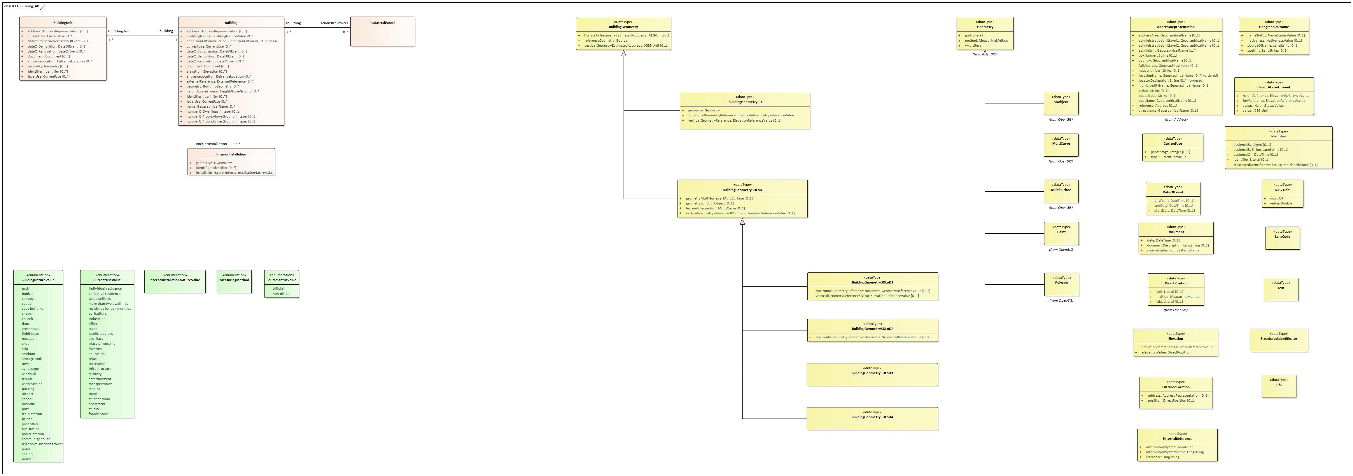
Entities
Building
- Description
- An enclosed and/or covered structure, above and/or below ground, intended either for the shelter of persons, animals or things, or for the production of economic goods or the provision of services, and refers to any structure permanently constructed or erected on its site.
- Properties
- For this entity the following properties are defined: address, building nature, building unit, cadastral parcel, condition of construction, current use, date of construction, date of demolition, date of renovation, document, elevation, entrance location, external reference, geometry, height above ground, identifier, interior installation, legal use, name, number of dwellings, number of floors above ground, number of floors under ground.
| Property | Expected Range | Cardinality | Description | Usage | Codelist |
|---|---|---|---|---|---|
address
|
Address representation | 0..* | The address representation that corresponds to the building. | ||
building nature
|
Building nature value | 0..* | Characteristic of the building that makes it generally of interest for mappings applications. The characteristic may be related to the physical aspect and/or to the function of the building. | This attribute focuses on the physical aspect (facade) of the building; however, this physical aspect is often expressed as a function (e.g. stadium, silo, windmill); this attribute aims to fulfil mainly mapping purposes and addresses only specific, noticeable buildings.
More information about the enumerations can be found on the INSPIRE Building Nature code list. |
|
building unit
|
Building unit | 0..* | Building unit(s) being part of the building. | ||
cadastral parcel
|
Cadastral parcel | 0..* | The parcel(s) with which the building is officially associated. | ||
condition of construction
|
ConditionOfConstructionValue | 1 | Values indicating the condition of a construction. | Concepts of this codelist should be used from the INSPIRE Condition of Construction code list. | |
current use
|
Current use | 0..* | Activity hosted within the building. This attribute addresses mainly the buildings hosting human activities. | This attribute aims to fulfill management requirements, such as computation of population or spatial planning ; this classification aims to be exhaustive for the functional buildings hosting human activities. | |
date of construction
|
Date of event | 0..1 | Date of construction. | ||
date of demolition
|
Date of event | 0..1 | Date of demolition. | ||
date of renovation
|
Date of event | 0..* | Date of renovation. | ||
document
|
Document | 0..* | Any document providing information about the building. | ||
elevation
|
Elevation | 0..* | Vertically-constrained dimensional property consisting of an absolute measure referenced to a well-defined surface which is commonly taken as origin (geoïd, water level, etc.). | ||
entrance location
|
Entrance location | 0..* | The location where the building can be entered or exited. | ||
external reference
|
External reference | 0..* | Reference to an external information system containing any piece of information related to the spatial object. | ||
geometry
|
Building geometry | 0..* | Shape and position characteristics of a building. | ||
height above ground
|
Height above ground | 0..* | Height above ground. | ||
identifier
|
Identifier | 0..* | Identifier of the Building. | ||
interior installation
|
Interior installation | 0..* | The interior installation(s) serving the building. | ||
legal use
|
Current use | 0..* | The legal use of the building. | ||
name
|
Geographical name | 0..* | Name of the building | ||
number of dwellings
|
Integer | 0..1 | Number of dwellings. A dwelling is a residential unit which may consist of one or several rooms designed for the occupation of households. | ||
number of floors above ground
|
Integer | 0..1 | Total number of building layers above ground, viewed across all building sections. | This starts usually from the level where the main entrance is located. | |
number of floors under ground
|
Integer | 0..1 | Total number of building layers under ground, viewed across all building sections. | This starts usually from the level where the main entrance is located. |
Building unit
- Description
- The smallest unit within a building that is suitable and adapted for residential, commercial or recreational purposes and which is accessible from the outside or from a common area. A building unit is atomic, functionally independent, and may be separately sold, rented out, inherited, etc. In addition, a building unit can also be a common part.
- Properties
- For this entity the following properties are defined: address, building, current use, date of construction, date of demolition, date of renovation, document, entrance location, geometry, identifier, legal use.
| Property | Expected Range | Cardinality | Description | Usage | Codelist |
|---|---|---|---|---|---|
address
|
Address representation | 0..* | The address representation that corresponds to the building unit. | ||
building
|
Building | 1 | Building of which building unit(s) are being a part. | The set of two distinct volumes united by a gallery/walkway is nevertheless considered as a single building. Two volumes separated by a footbridge (which is above a public road) are considered as two separate buildings which are located in different sites (because they are different plots). | |
current use
|
Current use | 0..* | Activity hosted within the building unit. This attribute addresses mainly the building units hosting human activities. | ||
date of construction
|
Date of event | 0..1 | Date of construction. | ||
date of demolition
|
Date of event | 0..1 | Date of demolition | ||
date of renovation
|
Date of event | 0..* | Date of renovation. | ||
document
|
Document | 0..* | Any document providing information about the building unit. | ||
entrance location
|
Entrance location | 0..* | The location where the building unit can be entered or exited. | ||
geometry
|
Geometry | 0..* | Shape and position characteristics of a building unit. | ||
identifier
|
Identifier | 0..* | The unique identifier of a building unit. | ||
legal use
|
Current use | 0..* | The legal use of the building unit. |
Cadastral parcel
- Description
- A portion of Belgian territory, geographically demarcated and identified by the AAPD on the cadastral plot plan, corresponding to the land area of one or more cadastral patrimonial plots.
- Properties
- For this entity the following properties are defined: building.
Interior installation
- Description
- An internal construction (generally or small size) or an internal device, serving the building.
- Usage
- Example: stairs, lift
- Properties
- For this entity the following properties are defined: geometry 3D, identifier, installation nature.
| Property | Expected Range | Cardinality | Description | Usage | Codelist |
|---|---|---|---|---|---|
geometry 3D
|
Geometry | 1 | 3D geometric representation of the internal installation. | ||
identifier
|
Identifier | 0..* | External unique object identifier published by the responsible body, which may be used by external applications to reference the spatial object. | ||
installation nature
|
Internal installation nature value | 1 | The nature of the internal installation. |
Datatypes
3D object
- Description
- A 3-dimensional geometric primitive.
- Subclass of
- Geometry
- Properties
- There are no properties defined for this datatype.
Address representation
- Description
- More readable representation with only the basic data of the address, intended to use an address as an attribute of another object.
- Usage
- The scope of this class is broad and is meant to capture generic address representations, aligned with INSPIRE. For Belgian addresses and derived implementations it is advised to align with BeST
- Properties
- we have defined the following properties for this datatype: address area, admin unit, administrative unit level 1, administrative unit level 2, box number, country, full address, housenumber, location name, locator designator, municipality name, po box, post name, postalcode, reference, streetname.
| Property | Expects Type | Cardinality | Description | Usage | Codelist |
|---|---|---|---|---|---|
address area
|
Geographical name | 0..1 | Name of a geographical area or locality that groups a number of addressable objects for the purpose of addressing them without the area or locality being an administrative unit. | ||
admin unit
|
Geographical name | 1..* | The name or names of a unit of administration where a Member State has and/or exercises jurisdictional rights, for local, regional and national governance. | ||
administrative unit level 1
|
Geographical name | 0..1 | Highest Administrative Unit of address, usually a country. | ||
administrative unit level 2
|
Geographical name | 0..1 | The region of the address, usually a province or state or similar area typically comprising several towns. | ||
box number
|
String | 0..1 | Officially assigned alphanumeric code added to the house number to distinguish multiple building units, pitches, moorings or plots that have the same house number. | While not advisable to do according to common BeST practices, optionally the block, floor, etc. can be specified here too. | |
country
|
Geographical name | 0..1 | Country in which the address is located. | ||
full address
|
Geographical name | 0..1 | The complete address in one string, formatted or not. | ||
housenumber
|
String | 0..1 | Alphanumeric code officially assigned to building units, berths, pitches or parcels. | This should be either purely numerical or a series of numbers followed by a letter. | |
location name
|
Geographical name | 0..* | Name or description of the geographic object that the address locator identifies. | ||
locator designator
|
String | 0..* | Alphanumeric code that uniquely identifies the address locator within the street, administrative unit, etc. | ||
municipality name
|
Geographical name | 0..1 | Municipal name of the address. | ||
po box
|
String | 0..1 | PO Box number in a post office. | ||
post name
|
Geographical name | 0..1 | Name designating the geographical area that groups addresses for postal purposes. | ||
postalcode
|
String | 0..1 | Code designating the geographical area that groups addresses for postal purposes. | ||
reference
|
Address | 0..1 | Address from which the address representation is derived. | ||
streetname
|
Geographical name | 0..1 | Streetname of the address. |
Building geometry
- Description
- This data types includes the geometry of the building and metadata information about which element of the building was captured and how.
- Properties
- we have defined the following properties for this datatype: horizontal geometry estimated accuracy, reference geometry, vertical geometry estimated accuracy.
| Property | Expects Type | Cardinality | Description | Usage | Codelist |
|---|---|---|---|---|---|
horizontal geometry estimated accuracy
|
ICEG-Unit | 0..1 | The estimated absolute positional accuracy of the (X,Y) coordinates of the building geometry. | ||
reference geometry
|
Boolean | 1 | The geometry to be taken into account by view services, for portrayal. | ||
vertical geometry estimated accuracy
|
ICEG-Unit | 0..1 | The estimated absolute positional accuracy of the Z-coordinate of the building geometry. | Absolute positional accuracy is defined as the mean value of the positional uncertainties for a set of positions where the positional uncertainties are defined as the distance between a measured position and what is considered as the corresponding true position. |
Building geometry 2D
- Description
- This data types includes the geometry in 2D or 2.5D of the building and metadata information about which element of the building was captured and how.
- Subclass of
- Building geometry
- Properties
- we have defined the following properties for this datatype: geometry, horizontal geometry reference, vertical geometry reference.
| Property | Expects Type | Cardinality | Description | Usage | Codelist |
|---|---|---|---|---|---|
geometry
|
Geometry | 1 | 2D or 2.5D geometric representation of the building. | ||
horizontal geometry reference
|
HorizontalGeometryReferenceValue | 1 | Element of the building that was captured by (X,Y) coordinates. | ||
vertical geometry reference
|
ElevationReferenceValue | 0..1 | Element of the building that was captured by vertical coordinates. | Concepts of this codelist should be used from the INSPIRE Elevation Reference code list. |
Building geometry 3D LoD
- Description
- Data type grouping the 3D geometry of a building or building part and the metadata information attached to this geometry.
- Usage
- More information about LoD can be found via this link: https://docs.ogc.org/is/20-010/20-010.html#toc0
- Subclass of
- Building geometry
- Properties
- we have defined the following properties for this datatype: geometry multi surface, geometry solid, terrain intersection, vertical geometry reference 3D bottom.
| Property | Expects Type | Cardinality | Description | Usage | Codelist |
|---|---|---|---|---|---|
geometry multi surface
|
Multi surface | 0..1 | Representation of the outer boundary by a Multi Surface, which may - in contrast to a solid representation - not be topologically clean. In particular, the ground surface may be missing. | ||
geometry solid
|
3D object | 0..1 | Representation of the outer boundary by a solid. | ||
terrain intersection
|
Multi curve | 0..1 | Line or multi-line where the spatial object touches the terrain representation. | ||
vertical geometry reference 3D bottom
|
ElevationReferenceValue | 0..1 | Height level to which the lower height of the model (Z-value of the lower horizontal polygon) refers to. | Concepts of this codelist should be used from the INSPIRE Elevation Reference code list. |
Building geometry 3D LoD1
- Description
- Data type grouping the specific metadata attached to the 3D geometry, when provided by a LoD 1 representation.
- Subclass of
- Building geometry 3D LoD
- Properties
- we have defined the following properties for this datatype: horizontal geometry reference, vertical geometry reference 3D top.
| Property | Expects Type | Cardinality | Description | Usage | Codelist |
|---|---|---|---|---|---|
horizontal geometry reference
|
HorizontalGeometryReferenceValue | 0..1 | Element of the real world object that was captured by the (X,Y) coordinates of the LoD1 Multisurface or Solid geometry. | Example: footprint, roof edge.
Concepts of this codelist should be used from the INSPIRE Horizontal Geometry Reference code list. |
|
vertical geometry reference 3D top
|
ElevationReferenceValue | 0..1 | Height level to which the upper height of the model (Z-value of the upper horizontal polygon) refers to. | Example: generalRoof, lowestRoof edge.
Concepts of this codelist should be used from the INSPIRE Elevation Reference code list. |
Building geometry 3D LoD2
- Description
- Data type grouping the specific metadata attached to the 3D geometry, when provided by a LoD2 representation.
- Subclass of
- Building geometry 3D LoD
- Properties
- we have defined the following properties for this datatype: horizontal geometry reference.
| Property | Expects Type | Cardinality | Description | Usage | Codelist |
|---|---|---|---|---|---|
horizontal geometry reference
|
HorizontalGeometryReferenceValue | 0..1 | Element that was captured by the (X,Y) coordinates of the LoD2 MultiSurface or Solid geometry. | Example: footprint, roof edge.
Concepts of this codelist should be used from the INSPIRE Horizontal Geometry Reference code list. |
Building geometry 3D LoD3
- Description
- Data type grouping the specific metadata attached to the 3D geometry, when provided by a LoD3 representation.
- Subclass of
- Building geometry 3D LoD
- Properties
- There are no properties defined for this datatype.
Building geometry 3D LoD4
- Description
- Data type grouping the specific metadata attached to the 3D geometry, when provided by a LoD4 representation.
- Subclass of
- Building geometry 3D LoD
- Properties
- There are no properties defined for this datatype.
Current use
- Description
- This data type enables to detail the current use(s).
- Properties
- we have defined the following properties for this datatype: percentage, type.
| Property | Expects Type | Cardinality | Description | Usage | Codelist |
|---|---|---|---|---|---|
percentage
|
Integer | 0..1 | The proportion of the building, given as a percentage, devoted to this current use. | ||
type
|
Current use value | 1 | The current use of a building. | Example: trade, entertainment, ... |
Date of event
- Description
- This data type includes the different possible ways to define the date of an event.
- Properties
- we have defined the following properties for this datatype: any point, end date, start date.
Document
- Description
- Any document providing information about a building or building unit.
- Usage
- EXAMPLES: the building permit, a photo of facade or inner yard, a sketch of interior, the building code, the energy performance assessment, an emergency plan
- Properties
- we have defined the following properties for this datatype: date, document description, source status.
| Property | Expects Type | Cardinality | Description | Usage | Codelist |
|---|---|---|---|---|---|
date
|
DateTime | 0..1 | Date of validity of the document. | EXAMPLES: the date the photo was taken, the date the sketch was done or approved, the date the building permit was accepted | |
document description
|
LangString | 0..1 | A short text providing overview of the document content. May be just title of the document. | ||
source status
|
Source status value | 1 | The status of the document, i.e. this attribute indicates if the document comes from official source or not. |
Elevation
- Description
- Vertically-constrained dimensional property consisting of an absolute measure referenced to a well-defined surface which is commonly taken as origin (geoïd, water level, etc.).
- Properties
- we have defined the following properties for this datatype: elevation reference, elevation value.
| Property | Expects Type | Cardinality | Description | Usage | Codelist |
|---|---|---|---|---|---|
elevation reference
|
ElevationReferenceValue | 1 | Element where the elevation was measured. | Concepts of this codelist should be used from the INSPIRE Elevation Reference code list. | |
elevation value
|
Direct position | 1 | Value of the elevation. |
Entrance location
| Property | Expects Type | Cardinality | Description | Usage | Codelist |
|---|---|---|---|---|---|
address
|
Address representation | 0..1 | The address linked to the location of the entrance. | ||
position
|
Direct position | 0..1 | Holder of the coordinates of a position in a coordinate reference system. |
External reference
- Description
- Reference to an external information system containing any piece of information related to the spatial object.
- Properties
- we have defined the following properties for this datatype: information system, informationSystemName, reference.
| Property | Expects Type | Cardinality | Description | Usage | Codelist |
|---|---|---|---|---|---|
information system
|
Identifier | 1 | Uniform Resource Identifier of the external information system. | ||
informationSystemName
|
LangString | 1 | The name of the external information system. | EXAMPLES: Danish Register of Dwellings, Spanish Cadastre | |
reference
|
LangString | 1 | Thematic identifier of the spatial object or of any piece of information related to the spatial object. |
Geographical name
- Description
- Proper noun applied to a real world entity.
- Usage
- This can be substituted by LangString
- Properties
- we have defined the following properties for this datatype: name status, nativeness, source of name, spelling.
| Property | Expects Type | Cardinality | Description | Usage | Codelist |
|---|---|---|---|---|---|
name status
|
NameStatusValue | 0..1 | Qualitative information enabling to discern which credit should be given to the name with respect to its standardisation and/or its topicality. | NOTE The Geographical Names application schema does not explicitly make a preference between different names (e.g. official endonyms) of a specific real world entity. The necessary information for making the preference (e.g. the linguistic status of the administrative or geographic area in question), for a certain use case, must be obtained from other data or information sources. For example, the status of the language of the name may be known through queries on the geometries of named places against the geometry of administrative units recorded in a certain source with the language statuses information. Concepts of this codelist should be used from the INSPIRE Name Status code list. | |
nativeness
|
NativenessValue | 0..1 | Information enabling to acknowledge if the name is the one that is/was used in the area where the spatial object is situated at the instant when the name is/was in use. | Concepts of this codelist should be used from the INSPIRE Nativeness code list. | |
source of name
|
LangString | 0..1 | Original data source from which the geographical name is taken from and integrated in the data set providing/publishing it. For some named spatial objects it might refer again to the publishing data set if no other information is available. | ||
spelling
|
LangString | 0..1 | A proper way of writing the geographical name. |
Height above ground
- Description
- Vertical distance (measured or estimated) between a low reference and a high reference.
- Properties
- we have defined the following properties for this datatype: height reference, low reference, status, value.
| Property | Expects Type | Cardinality | Description | Usage | Codelist |
|---|---|---|---|---|---|
height reference
|
ElevationReferenceValue | 1 | Element used as the high reference. | EXAMPLE: The height of the building has been captured up to the top of building.
Concepts of this codelist should be used from the INSPIRE Elevation Reference code list. |
|
low reference
|
ElevationReferenceValue | 1 | Element as the low reference. | EXAMPLE: the height of the building has been captured from its the lowest ground point. | |
status
|
HeightStatusValue | 1 | The way the height has been captured. | ||
value
|
ICEG-Unit | 1 | Value of the height above ground. |
ICEG-Unit
| Property | Expects Type | Cardinality | Description | Usage | Codelist |
|---|---|---|---|---|---|
uom
|
URI | 1 | Standard units of measurements used when accounting for stock, and expressing them in quantities. | Concepts of this codelist should be used from the EU Vocabulary Measurement unit. | |
value
|
Double | 1 | A property to relate a unit with a value. |
Identifier
- Description
- Information used to uniquely identify an object.
- Usage
- The basic assumption here is that this string is assigned by an organization and that this is done according to a well-defined system.
- Properties
- we have defined the following properties for this datatype: assigned by, assigned by string, assigned on, identifier, structured identificator.
| Property | Expects Type | Cardinality | Description | Usage | Codelist |
|---|---|---|---|---|---|
assigned by
|
Agent | 0..1 | Link to the agent who issued the identifier. | ||
assigned by string
|
LangString | 0..1 | Name of the agent who assigned the identifier. | ||
assigned on
|
DateTime | 0..1 | Time when the identifier was issued. | ||
identifier
|
Literal | 0..1 | String used to uniquely identify the object. | Type of the string refers to the identifier (incl its version), the string itself to the actual identifier. | |
structured identificator
|
Structured identificator | 0..1 | Identifier of the object broken down into its parts. |
Lang code
- Description
- The official code of the language.
- Properties
- There are no properties defined for this datatype.
Multi curve
- Description
- A MultiCurve is a 1-dimensional GeometryCollection whose elements are Curves.
- Subclass of
- Geometry
- Properties
- There are no properties defined for this datatype.
Multi surface
- Description
- A MultiSurface is a 2-dimensional GeometryCollection whose elements are Surfaces, all using coordinates from the same coordinate reference system.
- Subclass of
- Geometry
- Properties
- There are no properties defined for this datatype.
Point
- Description
- A 0-dimensional geometrical primitive.
- Subclass of
- Geometry
- Properties
- There are no properties defined for this datatype.
Polygon
- Description
- Surface consisting of one outer boundary and 0 or more inner boundaries. Each internal boundary forms a hole in the polygon.
- Subclass of
- Geometry
- Properties
- There are no properties defined for this datatype.
Structured identificator
- Description
- Identifier of an object broken down into its parts.
- Properties
- There are no properties defined for this datatype.
Text
- Description
- A linear sequence of characters, words, or other data.
- Properties
- There are no properties defined for this datatype.
URI
- Description
- A URI that is technically represented as a class in RDF, but is a literal in use.
- Properties
- There are no properties defined for this datatype.
Lists
(non-normative)Building Nature Value
- Definition
- Values indicating the nature of a building.
- PREFIX bnv:
- http://inspire.ec.europa.eu/codelist/BuildingNatureValue/
- PREFIX vbbnv:
- http://vocab.belgif.be/auth/building-nature-value/
SKOS TopConcepts
| URI | skos:prefLabel@en | skos:notation |
|---|---|---|
| vbbnv:airport | airport | airport |
| bnv:arch | arch | arch |
| bnv:bunker | bunker | bunker |
| bnv:canopy | canopy | canopy |
| vbbnv:casino | casino | casino |
| bnv:castle | castle | castle |
| bnv:caveBuilding | cave building | caveBuilding |
| bnv:chapel | chapel | chapel |
| bnv:church | church | church |
| vbbnv:communityHouse | community house | communityHouse |
| bnv:dam | dam | dam |
| vbbnv:fireStation | fire station | fireStation |
| bnv:greenhouse | greenhouse | greenhouse |
| vbbnv:hospital | hospital | hospital |
| vbbnv:hotel | hotel | hotel |
| vbbnv:house | house | house |
| bnv:lighthouse | lighthouse | lighthouse |
| bnv:mosque | mosque | mosque |
| vbbnv:parking | parking | parking |
| vbbnv:policeStation | police station | policeStation |
| vbbnv:port | port | port |
| vbbnv:postOffice | post office | postOffice |
| vbbnv:prison | prison | prison |
| vbbnv:school | school | school |
| bnv:shed | shed | shed |
| bnv:silo | silo | silo |
| bnv:stadium | stadium | stadium |
| bnv:storageTank | storage tank | storageTank |
| bnv:synagogue | synagogue | synagogue |
| vbbnv:telecommunicationsTower | telecommunications tower | telecommunicationsTower |
| bnv:temple | temple | temple |
| bnv:tower | tower | tower |
| vbnnv:trainStation | train station | trainStation |
| bnv:windTurbine | wind turbine | windTurbine |
| bnv:windmill | windmill | windmill |
Current Use Value
- Definition
- Values indicating the current use.
- PREFIX cuv:
- https://inspire.ec.europa.eu/codelist/CurrentUseValue/
- PREFIX vbcuv:
- http://vocab.belgif.be/auth/current-use-value/
SKOS TopConcepts
| URI | skos:prefLabel@en | skos:notation |
|---|---|---|
| cuv:agriculture | agriculture | agriculture |
| cuv:ancillary | ancillary | ancillary |
| vbcuv:apartment | apartment | apartment |
| cuv:collectiveResidence | collective residence | collectiveResidence |
| vbcuv:education | education | education |
| vbcuv:entertainment | entertainment | entertainment |
| vbcuv:familyHome | family home | familyHome |
| cuv:individualResidence | individual residence | individualResidence |
| cuv:industrial | industrial | industrial |
| vbcuv:infrastructure | infrastructure | infrastructure |
| vbcuv:lavatory | lavatory | lavatory |
| vbcuv:medical | medical | medical |
| vbcuv:military | military | military |
| cuv:moreThanTwoDwellings | more than two dwellings | moreThanTwoDwellings |
| cuv:office | office | office |
| vbcuv:placeOfWorship | place of worship | placeOfWorship |
| cuv:publicServices | public services | publicServices |
| vbcuv:recreation | recreation | recreation |
| cuv:residenceForCommunities | residence for communities | residenceForCommunities |
| vbcuv:retail | retail | retail |
| vbcuv:room | room | room |
| vbcuv:studentRoom | student room | studentRoom |
| vbcuv:studio | studio | studio |
| cuv:trade | trade | trade |
| vbcuv:transportation | transportation | transportation |
| cuv:twoDwellings | two dwellings | twoDwellings |
Internal Installation Nature Value
- Definition
- Code list for the possible values of the nature of an internal installation.
Measuring Method
- Definition
- The way something is measured.
Source Status Value
- Definition
- The status of the sources.
- PREFIX vbssv:
- http://vocab.belgif.be/auth/source-status-value/
SKOS TopConcepts
| URI | skos:prefLabel@en | skos:notation |
|---|---|---|
| vbssv:official | official | official |
| vbssv:non-official | non-official | non-official |
Changelog w.r.t. previous version
(non-normative)https://github.com/belgif/thematic/blob/master/models/building/readme.md
JSON-LD context
(non-normative)A reusable JSON-LD context definition is retrievable at: https://belgif.github.io/thematic/models/building/context/iceg-building_en.jsonld
SHACL template
(non-normative)A reusable SHACL template is retrievable at: https://belgif.github.io/thematic/models/building//shacl/iceg-building_en-SHACL.ttl